News   Apr 03, 2020
 5.8K     1 
News   Apr 02, 2020
 7.5K     3 
News   Apr 02, 2020
 4.4K     0 

Calgary Transit Fantasy Maps

Love all these plans and ideas!

Why does everyone always skip Chinook Centre though? It's the 9th largest mall in Canada currently. Chinook has got to be the single most popular destination south of downtown in the whole city - it already is the centre of a hub of activity today.

I've always thought a Chinook - Rockyview Hospital - MRU / Currie - Richmond Road 37th Street - Westbrook line would be killer. Add a more ambitious extension over the river to hit Foothills - University District - Market Mall - Dalhousie Red Line and you'll boost system ridership about 100%. It all starts with Chinook as the regional anchor as it already is.

For that matter, I don't really get why the existing MAX routes didn't try to hit it Chinook - maybe the bus circulation are tricky around the Chinook LRT / Glenmore interchanges?

Whatever the case surely a fantasy maps we should figure it out!
 
Here's an interesting idea that I've been working on a little bit, not as a high fantasy trains everywhere thing, but a more modest proposal. It's a set of additional/enhanced MAX BRT routes. Here's the MAX and LRT service as it exists (including the NC 301 which is actually a better service than any MAX):
View attachment 589765

And then this is the core of the proposal, which adds two MAX lines (shown in rose and mint) and extends the purple.
View attachment 589766
The purple is now a through service, connecting the downtown to the U of C/Foothills area and then on up Shagnappi to North Pointe. The rose and mint are circumferential north-south routes. Rose connects Saddleridge to Somerset via 52 St, the SE industrial and South Health campus. Mint connects Crowfoot to Somerset via Bowness, Sirocco LRT, Westhills and Buffalo Run.

But you may have noticed that some of the lines extend past the page. Here are the four regional MAX routes I propose (in the interest of saving data, I've used thumbnails for the detailed routes): To give them a stupid name, I'll call them Regional MAX, or ReMAX for short.
ReMAX Orange: Airdrie to Cochrane, connecting the north and south Airdrie transit hubs with west Airdrie, Cross Iron Mills and vicinity, then the existing orange route, extending to Crowfoot and then on to central Cochrane. (Cochrane's road layout cannot meaningfully be served by transit.)
View attachment 589772


ReMAX Purple: Airdrie to Strathmore, including central Airdrie, Cross Iron Mills, North Pointe, U of C, downtown, then the existing purple route with a more streamlined through run of Chestermere and on to Strathmore.
View attachment 589773


ReMAX Mint: Cochrane to Diamond Valley, connecting Crowfoot, Bowness, Sirocco, Westhills, Buffalo Run, Evergreen and running through Okotoks
View attachment 589774


ReMAX Rose: Crossfield to High River, connecting east Airdrie, the airport, the 52nd St corridor (stopping at the same places as Orange, my mistake), South Health Campus and then on to Okotoks
View attachment 589775


And then putting it all together, we would have:
View attachment 589767

Assuming half hourly frequency to start, this layout would actually result in 30 minute headways most places, but 20 minutes to Okotoks and Cochrane, and 10 minutes to Airdrie effectively.

To be slightly more practical, lines this long are really difficult to keep schedule to, and I don't know that it actually makes that much sense to do this much through-running. However, one service pattern that could make sense would be having alternate trips go out of town at each end. For example, a ReMAX Orange stop westbound on 16th Ave could have the following pattern:

From Time To
Saddletowne 8:00 Brentwood
Airdrie 8:07 Brentwood
Saddletowne 8:15 Brentwood
Saddletowne 8:22 Cochrane
Saddletowne 8:30 Brentwood (repeating)

where the regional runs alternate with in-city runs, and the buses that do regional runs only go into the region on alternate directions. It would be a little more complex to use (although we already refer to LRT lines by their end stations) and would make region-to-region trips a little slower, although to be honest, if you're on the bus that long you need a bathroom break anyways.
Great detail, and some very interesting ideas there!

Ultimately I think regional rail would replace a fair bit of the exurb portion, but it would be a good way to get service started and gauge real world demand for routes.
 
I've always thought a Chinook - Rockyview Hospital - MRU / Currie - Richmond Road 37th Street - Westbrook line would be killer. Add a more ambitious extension over the river to hit Foothills - University District - Market Mall - Dalhousie Red Line and you'll boost system ridership about 100%. It all starts with Chinook as the regional anchor as it already is.

For that matter, I don't really get why the existing MAX routes didn't try to hit it Chinook - maybe the bus circulation are tricky around the Chinook LRT / Glenmore interchanges?
The existing route 9 runs from 37 Street & MRU to Chinook, and since there are very few stops between MRU and Chinook a BRT would offer little advantage over the current service (hence the MAX Teal going to Heritage instead). For that matter, the 9 successfully runs more-or-less the exact routing you described (albeit skipping U district/Market Mall and cutting right thru the university itself on Campus Drive, stopping at Brentwood Mall and then continuing to Dalhousie).
 
Here's an interesting idea that I've been working on a little bit, not as a high fantasy trains everywhere thing, but a more modest proposal. It's a set of additional/enhanced MAX BRT routes. Here's the MAX and LRT service as it exists (including the NC 301 which is actually a better service than any MAX):
View attachment 589765

And then this is the core of the proposal, which adds two MAX lines (shown in rose and mint) and extends the purple.
View attachment 589766
The purple is now a through service, connecting the downtown to the U of C/Foothills area and then on up Shagnappi to North Pointe. The rose and mint are circumferential north-south routes. Rose connects Saddleridge to Somerset via 52 St, the SE industrial and South Health campus. Mint connects Crowfoot to Somerset via Bowness, Sirocco LRT, Westhills and Buffalo Run.

But you may have noticed that some of the lines extend past the page. Here are the four regional MAX routes I propose (in the interest of saving data, I've used thumbnails for the detailed routes): To give them a stupid name, I'll call them Regional MAX, or ReMAX for short.
ReMAX Orange: Airdrie to Cochrane, connecting the north and south Airdrie transit hubs with west Airdrie, Cross Iron Mills and vicinity, then the existing orange route, extending to Crowfoot and then on to central Cochrane. (Cochrane's road layout cannot meaningfully be served by transit.)
View attachment 589772


ReMAX Purple: Airdrie to Strathmore, including central Airdrie, Cross Iron Mills, North Pointe, U of C, downtown, then the existing purple route with a more streamlined through run of Chestermere and on to Strathmore.
View attachment 589773


ReMAX Mint: Cochrane to Diamond Valley, connecting Crowfoot, Bowness, Sirocco, Westhills, Buffalo Run, Evergreen and running through Okotoks
View attachment 589774


ReMAX Rose: Crossfield to High River, connecting east Airdrie, the airport, the 52nd St corridor (stopping at the same places as Orange, my mistake), South Health Campus and then on to Okotoks
View attachment 589775


And then putting it all together, we would have:
View attachment 589767

Assuming half hourly frequency to start, this layout would actually result in 30 minute headways most places, but 20 minutes to Okotoks and Cochrane, and 10 minutes to Airdrie effectively.

To be slightly more practical, lines this long are really difficult to keep schedule to, and I don't know that it actually makes that much sense to do this much through-running. However, one service pattern that could make sense would be having alternate trips go out of town at each end. For example, a ReMAX Orange stop westbound on 16th Ave could have the following pattern:

From Time To
Saddletowne 8:00 Brentwood
Airdrie 8:07 Brentwood
Saddletowne 8:15 Brentwood
Saddletowne 8:22 Cochrane
Saddletowne 8:30 Brentwood (repeating)

where the regional runs alternate with in-city runs, and the buses that do regional runs only go into the region on alternate directions. It would be a little more complex to use (although we already refer to LRT lines by their end stations) and would make region-to-region trips a little slower, although to be honest, if you're on the bus that long you need a bathroom break anyways.
Wow, that’s really impressive. Thanks for putting all that work in. The city should actually look at this 😅 I feel like if we had a more solid regional strategy for infrastructure development, like this, developers would move on our next layer of bedroom communities.
 
1725596226418.png
 
This is my Calgary Hindsight Map...if we knew everything we know today and could rewind 15-20 years, this would have been a cool outcome. But still ripe with challenges and the order of building would be a little funky - likely start with SE BRT, then gold and silver lines, 8th ave subway, and finally convert GL to LRT)

Gold and silver lines are really the same line, all using LF. GL would be HF.

https://metrodreamin.com/view/MjJEb3Y3UVRvblFIY1huaTZVaUZSVDBoRUZKM3ww
The circles on the map are meaningless...they are animated trains moving randomly within the website

Screenshot 2024-09-24 at 10.56.10 AM.png


Screenshot 2024-09-24 at 10.56.56 AM.png


It requires:

800 meters shallow cut/cover for silver line (1 UG station)
500 meters shallow cut/cover on 12 Ave to link with red line DT underpass (1 UG station build in conjunction with arena)

That's it (remainder of green line and 8th Ave subway are the same as today's eventuality). It essentially cuts out:

- ~2000m green line tunnel, it's 2-4 UG stations, bridge across the Bow
and west line stuff:
- 1500m elevated CP crossing with Sunalta station
- 1200m tunnel with UG Westbrook station
- Another couple kms or so of trenching + earthwork + an extra bridge component on 17th Ave interchange + 69th St tunnel/UG station
- Also, all of the 17th ave street works would have coincided; conceivably the 37th St Main Street project, too (though realistically it would be the last thing built on this map so probably not quite done by 2024)

Of course this isn't to say that laying track on urban streets is always cheaper/simpler than above, but we've also done a lot of streetscape stuff on a bunch of these alignments. I'd envision losing a lot of vehicle capacity on 1st St SW and 17th Ave...but we're in Fantasyland so why not!
 
I like that. Then also the blue line could have been extended to Bowness as the West Central line, then the Purple Line spurring off the Green Line for the 17th Southeast route.
 
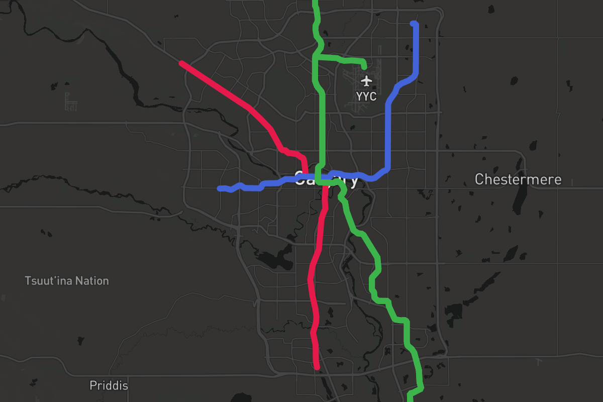
A simple fantasy: what if the green line was automated light metro (like SkyTrain), and had an airport branch just like the Canada Line?
1727488205989.png

Then you can build the North Central Airport branch before going to the SE, with the depot going in the Aero industrial area instead of Shepard
 
A simple fantasy: what if the green line was automated light metro (like SkyTrain), and had an airport branch just like the Canada Line?
View attachment 599819
Then you can build the North Central Airport branch before going to the SE, with the depot going in the Aero industrial area instead of Shepard

I like it, more or less what I had in mind for an ideal GL. Could be beneficial to extend the airport spur to the blue line to maximize the network effect.

I still think HSR should link into the airport as well, but there's nothing wrong with doing both!
 
Love all these plans and ideas!

Why does everyone always skip Chinook Centre though? It's the 9th largest mall in Canada currently. Chinook has got to be the single most popular destination south of downtown in the whole city - it already is the centre of a hub of activity today.

I've always thought a Chinook - Rockyview Hospital - MRU / Currie - Richmond Road 37th Street - Westbrook line would be killer. Add a more ambitious extension over the river to hit Foothills - University District - Market Mall - Dalhousie Red Line and you'll boost system ridership about 100%. It all starts with Chinook as the regional anchor as it already is.

For that matter, I don't really get why the existing MAX routes didn't try to hit it Chinook - maybe the bus circulation are tricky around the Chinook LRT / Glenmore interchanges?

Whatever the case surely a fantasy maps we should figure it out!
That’s apart of the my main transit idea we need a circle line sooner than later due to the new traffic patterns post Covid with WFH lessening the need for a central radial line system.

The Circle Line would have to be high floor.

You have covered the western part of the circle.

From Chinook East I would have the train to travel along Glenmore turning off inbetween Burbank Road and 10St SE.

Then working towards the Green Line and having Lynnwood as transfer station.

Move the station north so it lines more with CN’s ROW.

The line would then extend on that right of away.

Then turns onto 36th and would link into Marlborough. Allow a possibility of a future spur line to serve Penbrooke, Applewood etc.

The final section is extending the blue line from 88th Ave to the old 96th Green Line station.

Have it then extend west and run along Country Hill Boulevard. Then turning at Shaganappi Trail going down to the Red Line Infill station at Northland and would connect to Market Mall and the prior stated line.


This is why I’m against the Lircon Regional Transit idea is we cannot allow an non C-Train system go to the airport.

We should have a regional / highspeed train connection around Nose Creek & 96th.
Loricon only cares about transit to the airport because the Canada infrastructure bank said transit to the airport adds a lot of customers to liricons Calgary-Banff project and made their financing for the private part subject to building the public part to the airport. The airport was convinced to dedicate airport improvement fees to the project as well with transport Canada matching. Still leaves a $500-$700 gap for traditional public infrastructure dollars to spend.

I don’t see lrt and the link as competing because there isn’t a world where an airport lrt is built as a priority. It is a project that sounds a lot better than it is. While the downtown link combined with the Banff link is a project that is better than it sounds.
 
That’s apart of the my main transit idea we need a circle line sooner than later due to the new traffic patterns post Covid with WFH lessening the need for a central radial line system.

The Circle Line would have to be high floor.

You have covered the western part of the circle.

From Chinook East I would have the train to travel along Glenmore turning off inbetween Burbank Road and 10St SE.

Then working towards the Green Line and having Lynnwood as transfer station.

Move the station north so it lines more with CN’s ROW.

The line would then extend on that right of away.

Then turns onto 36th and would link into Marlborough. Allow a possibility of a future spur line to serve Penbrooke, Applewood etc.

The final section is extending the blue line from 88th Ave to the old 96th Green Line station.

Have it then extend west and run along Country Hill Boulevard. Then turning at Shaganappi Trail going down to the Red Line Infill station at Northland and would connect to Market Mall and the prior stated line.


This is why I’m against the Lircon Regional Transit idea is we cannot allow an non C-Train system go to the airport.

We should have a regional / highspeed train connection around Nose Creek & 96th.
I like the idea of a circle line as well, it would really tie the network together.
Nose hill does present a pretty huge obstacle in the north though, maybe more of a horseshoe line would work better?

Can you elaborate on your opposition to having heavy rail to YYC?
While LRT access there would still be good, having a direct non stop connection to DT would be enormously useful as well.
 
Loricon only cares about transit to the airport because the Canada infrastructure bank said transit to the airport adds a lot of customers to liricons Calgary-Banff project and made their financing for the private part subject to building the public part to the airport. The airport was convinced to dedicate airport improvement fees to the project as well with transport Canada matching. Still leaves a $500-$700 gap for traditional public infrastructure dollars to spend.

I don’t see lrt and the link as competing because there isn’t a world where an airport lrt is built as a priority. It is a project that sounds a lot better than it is. While the downtown link combined with the Banff link is a project that is better than it sounds.
I do really like the idea of the YYC/DT/Banff rail link, but ultimately I think the airport would be best served by switching the DT link to a HSR line that also connected to YEG on the way to Edmonton. The Banff rail row in nose creek could then be refocused on commuter rail up to Airdrie.
Hopefully any rail link to YYC can be built with this flexibility in mind.
 
ultimately I think the airport would be best served by switching the DT link to a HSR line that also connected to YEG on the way to Edmonton. The Banff rail row in nose creek could then be refocused on commuter rail up to Airdrie.
Hopefully any rail link to YYC can be built with this flexibility in mind.
Bingo yes.
 

Back
Top