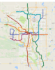
Here's my fantasy C-Train / Commuter Rail System
View attachment 126775
View attachment 126778
The Blue Line
The core the line is identical to what exists today. In the North East, I've added an envisioned extension up to Sky View. This is obviously a pretty long ways out, but eventually the demand would get to the point where the extension would become logical. The loop on the west side of of the line is the result of what you might call serious "West Calgary Homerism." I know it's definitely on the
fantastical side, but I envisioned it because I think the West Side has a fair bit to offer, but in the current state of affairs it's a bit of a drivers hell. I think my loop could really reinvigorate it. Aspen is in the long term plans I believe, but I decided to try to help out some of the other communities and the nascent commercial area on 85th by bringing them all to the party. Even Coach Hill / Patterson has an area that could really benefit from the opportunity to develop a denser core.
The Red Line
This is the line I toyed with the least. I thought about ripping off googspecial's cool spur, but ultimately left it as is. The biggest changes are the addition of Northland Station between Dalhousie and Brentwood and the addition of Silverado Station at the far south end. Both of these stations are already in the city plans I believe.
The Green Line
It's exactly as the city has it on their website, just with some renamed stations are a few shared stations with my later fantasy lines. It has the full extension out to 160th avenue north. I noticed that 9th Ave. N is no longer on the city's map. I have it here, but does anyone know if it's been dropped IRL?
The Yellow Line
This is an outer ring line. Many of the rudaments are shared in
@googspecial 's, but it goes a couple of steps further by being entirely a train line and by completing a full circuit. The more I think about it, the more I think it might actually make sense to bump down the southern portion so that it reaches into the Braeside area, but I like it the way it is for now. Critically, this line would connect MRU, The Foothills, the Rockyview and the Alberta Childrens hospital with the C-Train. It would likely have to be built in phases and the River Crossing into Spruce Cliff would likely be an expensive engineering feat. This is fantasy though, so this is what I'd like to see.
The Orange Line
Similar to
@googspecial 's Purple Line and
@Silence&Motion 's Orange Line, my orange line also goes out towards Bowness in the West. The big difference is that is passes along the Trans Canada rather than through the communities. It has a station right at Winsport and a terminus at Valley Ridge. The central portion is novel though. Rather than going along 16th Ave. N like the other lines, it instead continues to hug the river and ultimately goes up Kensington Road. Probably not the most feasible thing to accomplish cost effectively, but I really like the idea of a C-Train that passes through Kensington. Also expensively, it then tunnels under the river and joins up with the Green Line until Ramsay. At which point it sails along 17th Ave SE to the edge of town. Another apparently popular line choice.
The Purple Line
Somewhat similar to spurs on both your lines, this version takes it a little further and pushes it out highway 8. It follows it's own path up Crowchild to hit MRU, Currie and Marda loop. This stretch could just as easily be shared with the Yellow Line realistically. It eventually heads downtown. I put it on 15th ave rather than 17th, because I thought of it as a surface line, but tunneling makes fantasy, if not monetary sense. This is the main line for servicing the Beltline with stops near Western Canada High School and the Sheldon Chumir. It then joins up with the Green and Orange Lines and heads west. Rather than going to the edge of town it eventually veers south to catch Dover and the Eastfield industrial area before terminating at the Greenline Lynwood Station.
The Sky Blue Line
Going for a theme with the colour.

it's part airport spur, part North Calgary collector and part NE Calgary express. It also links up with an imagined commuter rail station west of the airport before getting to the Green Line.
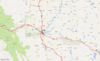
Commuter Rail
I did it up fantasy stiles going as far as Nanton, Banff, Red Deer and Strathmore hitting up most stops along the way. Realistically, demand would drive how far the lines would run and how frequently it stops. The central station also invisages blowing up the parking garages around the Calgary Tower and in a sense elaborates on an Crazy Dream Idea I had for re imagining the Tower as a transportation focal point and starting point for visitors to the city. There are also four cardinal point stations in or near the city at Bowness, Chestermere, Dewinton and the aforementioned North Calgary station in the Sky Blue Line.
Feasible? Probably not, but that's not the point of fantasy. I think my plan touches on a number of similar themes though. A line that goes Due-East/Due-West to Winsport and Elliston Park, a line that goes to MRU and a line that goes to the airport. If those become the next priorities after the Green Line, I think I'll be pretty happy even without my West Calgary Love Letter Loop and my giant golden ring.
NOTE: I can't share my navigable my maps station map yet, but I intend to later today. Here's a couple preview shots.
View attachment 126779
View attachment 126780
View attachment 126781