CalgaryTiger
Senior Member
I don't think so... there are homes on either side of Seton Way.get it down to 212th and then turn due east.
Could turn east before Main Street. But there is still no right-of-way there.
I don't think so... there are homes on either side of Seton Way.get it down to 212th and then turn due east.
Good question, maybe I'm missing something. I just assumed they'd use the ROW that's been vacant for decades.So, the green line website is wrong on the high-level station layout?
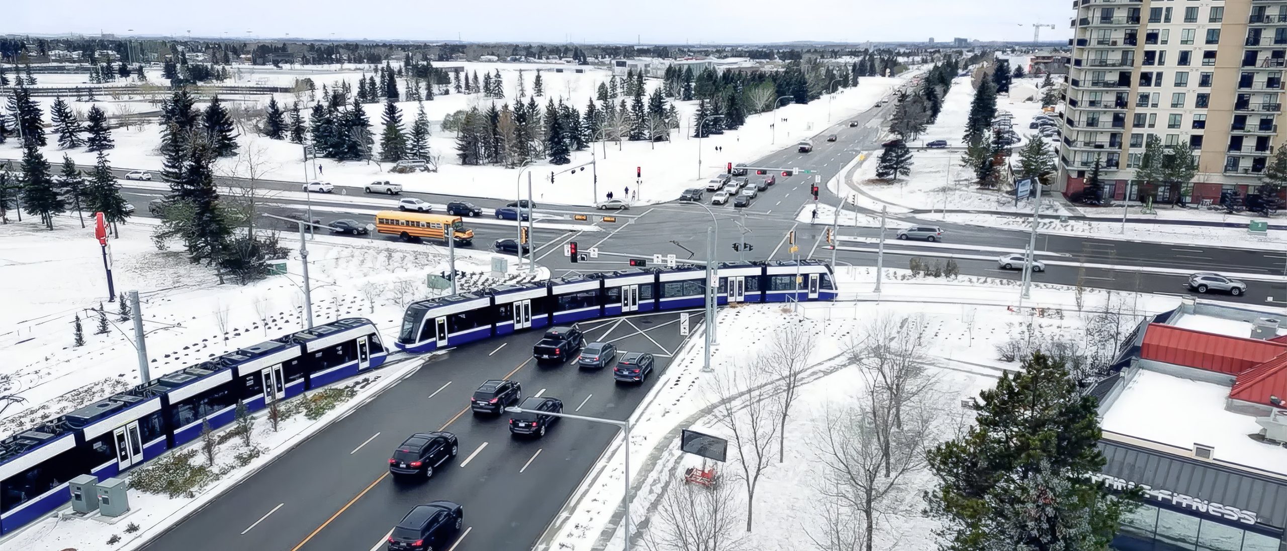
From inside edges of sidewalks (MUPs) its generally about 29 meters wide. On either side of the Main St circle it briefly shrinks to just 24 meters. Compared to Centre St north that has long stretches where it's just 19 meters wide.I don't think so... there are homes on either side of Seton Way.
View attachment 699320
Gotta cross Stoney, navigate Cranston and its tricky topography and then cross the Bow River, and then I think another pretty big hill to climb. And it would be like 6 kms. An aerial tram/gondola would be a cool way to connect, but that distance is too far IMO.I thought it would be interesting if GL could go west from there instead and connect with RL at 210 av. Maximize network effect and all that
Right, but that's where it stops.I am pretty sure this is the reserved ROW through Seton for the future Greenline:
View attachment 699329
That final curve now looks very obvious. But this also makes it look even more boxed in...I am pretty sure this is the reserved ROW through Seton for the future Greenline:
View attachment 699329
The map here is definitely just drawn wrong.This alignment confuses me, are they not using the right of way? At this point I'm only counting 29th Street (2).
I think in a really old version of the alignment it was elevated over HighfieldIt's too bad. I really wish they'd build an overpass for the LRT crossing at Highfield Blvd. There's already one there for freight:
The line will run at ground level and pass underneath the spur through a tunnel that was completed about 3 years ago:I never noticed the conflicts with some spur lines here - it looks like at least one of them is still in service (near the top centre of this photo you can see 4 train cars on the east side of the building that's just south of the bunch of school buses parked - it's called Hood Plastics on google maps). Does it stay elevated from Blackfoot Tr until just before Highfield Station?
I remember at some point there was a discussion about changing the location of Quarry Park Station, and that meant changing the alignment so that it could no longer follow the reserved ROW, so maybe it was quietly done and got overshadowed by the provincial debacle of the past few yearsThe map here is definitely just drawn wrong.
I took a closer look and not only would it add 4 train-vehicle crossings, there's currently large distribution power lines right where it shows as well. On the actual alignment map on the green line website, it aligns with the reserved ROW as well.I remember at some point there was a discussion about changing the location of Quarry Park Station, and that meant changing the alignment so that it could no longer follow the reserved ROW, so maybe it was quietly done and got overshadowed by the provincial debacle of the past few years
There actually is a ROW south of Market Street. If you look between the fire station and the red blue lego condos plus Randy O-Dell House you can see it just off Main street and Seton Drive. There’s also a field just beside the YMCA on the NW corner where a station is supposed to go:It is possible they could put in a trench like they did with 69th Street station on the Blue Line.
One thing I've noticed, now that they're building Seton out is that there is no right of way south of what they call Main Street SE. I know it is hard to imagine but by the time the train gets to Seton it will be near full buildout, and the city would have likely expanded east. Interesting there is no obvious right of way.
Aren’t the crossings going to be grade separated? That means it won’t be so slow I would assume.A cautionary tale regarding street running trams - looking at you Center Street N. Green Line
Edmonton Valley Line LRT ridership falls far short of estimates - SkyTrain for Surrey, not LRT!
Despite recent cost increases, the SLS remains Canada's best value transit project, costing less per-kilometre than many surface LRT proposals.skytrainforsurrey.org
