News   Apr 03, 2020
 4.6K     1 
News   Apr 02, 2020
 6.5K     3 
News   Apr 02, 2020
 3.7K     0 

Calgary Bike Lanes and Bike Paths

Good read concerning the new cycle tracks

https://slowstreets.wordpress.com/2...al&utm_source=twitter.com&utm_campaign=buffer


p6258480.jpg
 
City to host party to celebrate 1 Million cycle trips on cycle track network.
https://www.facebook.com/events/495876097290359/?notif_t=event_aggregate&notif_id=1471274765267186

Details
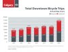
Come cheer on all the people on bikes crossing the bike counter as we hit the ONE MILLION mark on the Cycle Track Network. Bring your cowbells and noise makers and be part of this historic moment!

Get your bike portrait with People on Bikes YYC resident photographer, Masa Higuchi, who will be on hand snapping photos.

Meet the City of Calgary bike team and chat with them about the cycle track network.

FREE cookies for all!

WHEN: Wednesday, August 17 from 4:00-6:00 p.m.
WHERE: 5 Street & 9 Avenue S.W. by the bike counter beside the CPR underpass.

AFTERPARTY at 6PM at the Unicorn Super Pub on Stephen Ave.
 
Over the past year, I've had a lot of opportunities to extensively use Toronto's new bike lanes, and I think there are a few lessons for Calgary. Toronto (inner city) has had relatively high ridership considering it had almost zero infrastructure until recently. There has been A LOT of action on bikes in the big smoke over the past couple of years. First of all, there are a few differences between Toronto and Calgary that I will highlight.
  • As you all know, Toronto is a sprawling (mega)city, but its central business district (~10 km2) and inner core (~100 km2) are highly densified and lay on a nearly uninterrupted grid street network. Calgary by contrast has a CBD of about ~2 km2 and a surrounding inner-city of ~10 km2. Toronto's never-ending street grid network expands out into the distant suburbs. The GTA has hardly any regional mixed-use trails, and very poor transit beyond Toronto proper city limits. Calgary by contrast has decent transit throughout (considering relatively low density in most suburbs) and ~800 km of mixed use trails. Cycling is frankly not an option in the outer GTA except to the most extreme riders. Moreover, even the least-walkable/bikeable suburbs in Calgary has decent sidewalk standards (with several exceptions), whereas sidewalks in the distant GTA suburbs are often immediately adjacent to high-speed traffic or absent in industrial areas. That said, both cities have much variability in infrastructure as one approaches distant greenfield and brownfield. With regards to climate, Toronto is FAR warmer and more humid for the duration of the summer. Expect to arrive everywhere sweaty unless you travel with AC. In winter, the cities get comparable levels of snowfall, but this is especially problematic for cyclists in Toronto where roads are generally more narrow in older neighbourhoods. Of course, Calgary gets Chinooks and bright skies all year. Residents of both cities complain and make excuses not to bike. Traffic is obviously much heavier in Toronto, although I've noticed that Calgary is more vulnerable to major delays caused by a single incident, as in most Toronto neighbourhoods, the grid offers many alternatives. Torontonians expect getting anywhere to take a long time, and they are always right about that, accident or no. It is common for a trip that takes 22 minutes by car to also take 22 minutes by transit and 22 minutes by bike.
  • Toronto launched bike sharing in 2011, and the Toronto Parking Authority took over service in 2013. Bikes sport decals of sponsors as well as promotion of special events in the city, such as Pride. This summer, Toronto Bike Share underwent a massive expansion.
  • The Waterfront Trail was massively improved through downtown Toronto's waterfront in 2015 for the PanAm Games. It is essentially a separated bike lane from one end of Downtown to the other. Last year, I rode this "trail" all the way from Toronto to Prince Edward County (~250k) and discovered there are many gaps as soon as you reach the end of Downtown. The main pitfall downtown has nothing to do with the quality of the cycle track, but with the huge crowds of tourists that always occupy that stretch. One is certain to have to dodge people who have wandered into the bike lane.
  • Shaw, Harbord, Bloor, College, Adelaide, Richmond, Christie, etc, Bike lanes. These are the best successes of Toronto's bike infrastructure in my opinion. However, there are many problems. For the most part, these lanes are separated only by paint, with the occasional flexi-bollard on some routes. On the positive side, all of these lanes were built at minimal costs and are HIGHLY used. I'd wager that every one of these lanes gets more bike traffic than any of Calgary's lanes. That is not to say that Calgary's lanes are not a success - they ARE - but it's a matter of population density and available transportation options. Although it is common to need to dodge a turning car, jogger, motorcycle, or parked truck in Toronto's bike lanes, one feels safety in numbers. Perhaps what impressed me most is how quickly these lanes were built. Bloor lanes were installed in a single evening with signage and signalling installed over the next couple of days. Road closure was not an option. Already in the year I've been frequenting Toronto lanes, I've noticed a substantial increase in cyclists. Bike-traffic is a good thing, right? It's also worth noting that nearly every road has some bike traffic, and even adjacent streets have well-marked lanes (i.e. Bloor and Harbord).
Anyway, as every Canadian city moves closer and closer to a cyclist's utopia, it's been interesting to see how it has changed our biggest, most auto-oriented metropolis. There is still much work to do, but I suppose that my take home message is that change can happen FAST when the right pieces are in place. Hopefully cycling becomes safer and easier in more Toronto and Calgary neighbourhoods in the near future.
 
Well written Rlucky! I've never cycled in Toronto before and don't know much about its cycling infranstructure, but it looks like they are going in the right direction. I'm also happy with the direction Calgary is going. Still work to do of course, but the fact they got the cycle tracks going makes me optimistic for more. Are you originally from Calgary?
 
I grew up in Calgary and have spent most of my adult life there. I've worked in every quadrant of the city and biked extensively throughout. I'm very pleased with the new lanes so far, but still encounter some pretty oppressive motorists now and then. It happens in Toronto too from time to time (the most common move is pulling as far to the right as possible so a bike can't fit through) but it is massively tempered by the slow speeds. In both cities I hear negative, idiotic attitudes about cyclists, especially from middle aged people at the work place, etc.

The more I think about the success of cycling in Toronto, the more I think it comes down to the fact that it is definitely the fastest way to get around town, especially if you factor in time looking for a parking spot. Toronto excels at having bike racks everywhere. Biking is also by far the cheapest, next to walking (3.25 for TTC).

Calgary could use more bike racks ("ring and stick" should line every sidewalk in the inner city.

One last observation: Other than parking enforcement, Toronto has next to zero traffic enforcement. Almost nobody gets speeding tickets, dangerous driving infractions, jaywalking, or any punitive measure for the wild and dangerous things they do - drivers and cyclists alike. The result is a sort of common sense law that took me a while to get used to. I can't say whether it's the right approach, but I think it lessens the tension between modes I'm a system that was designed entirely for cars.
 
Bridgeland portion of Cycle Track opens. Very good to see, although I still wish this portion went all the way up the hill along Edmonton Trail.
pics from @DaleCalkins on Twitter

Image24.jpg
Image23.jpg
 

Attachments

  • Image24.jpg
    Image24.jpg
    153.2 KB · Views: 568
  • Image23.jpg
    Image23.jpg
    169.3 KB · Views: 446
Looks awesome and should really change the feel of Edmonton Trail. This is a big win for Bridge land. It's not clear how it connects to 8th Ave NE or various North routes, but there are a ton of low speed roads that cut through the nearby communities, so hopefully more cyclists give it a try.
 
Looks awesome and should really change the feel of Edmonton Trail. This is a big win for Bridge land. It's not clear how it connects to 8th Ave NE or various North routes, but there are a ton of low speed roads that cut through the nearby communities, so hopefully more cyclists give it a try.
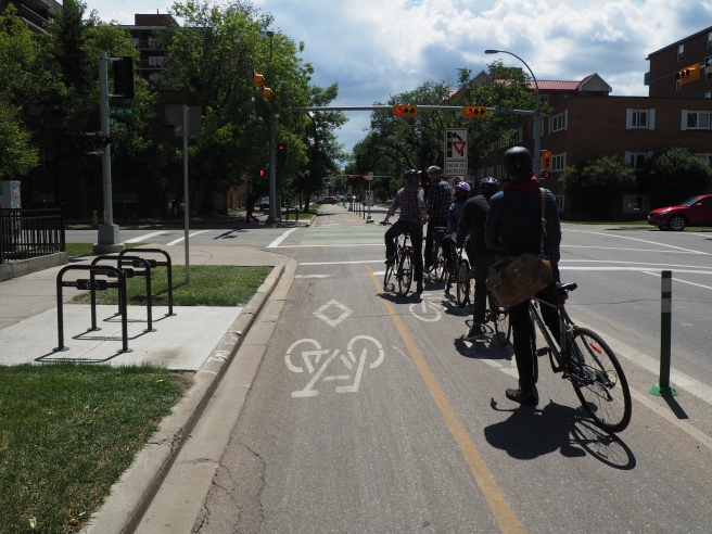
Right now the cycle track ends abruptly where northbound and southbound Edmonton Trail lanes meet. They'll have to figure a way to get it to carry on, but this is a good start.
 
I love the initiative, but having it suddenly end where it does is a fail imo. It's a nice little stretch of track, but doesn't carry through consistently at either end of the track. I wish they had have built it on the opposite side of the road and had it continue up Edmonton Trail.

Aside from that, yesterday I took a nice fall day run around some of the downtown cycle tracks. I can sum it up in word... 'great'. I was pleasantly surprised to see a number of mothers with kids presumably cycling on the way home from school.
 
I've changed my mind a bit about the Edmonton Trail cycle path. It needs to go further up the hill somehow, but overall isn't a fail. I rode my bike over to Beakernight on Saturday (which by the way was awesome) and took the bike path along the river and connected over to the cycle track and then over to Centre ave in Bridgeland. The cycle track made a nice connection into Bridgeland. :cool:
 
While it certainly matters how our bike lanes connect when we have so few, Edmonton Trail is almost a success even if it is hardly used. The reason is because that section of Edmonton trail is about 2 lanes wider than it will ever need to be (4 lanes wide, but a 3 lane bottleneck to the south and a 2 lane bottle neck at the north). The cost of installation and disruption to traffic is almost negligible, and Bridgeland now has another transportation option for families, people who don't drive or can't afford cars, etc. I think Bridgeland, Renfrew, and Tuxedo Park with see a bit of densification in the coming decades.

We've all said it a million times, but what really would have helped accessibility in Bridgeland is if the George C King Bridge crossed Memorial.

Maybe we could get a simple painted lane down 1st Ave.

Agreed. Regardless of how much the Edmonton Trail section gets used (and I have seen people using it) it was a wide stretch of road that wasn't fully utilized anyway.

Totally agree about the George C King bridge.
 

Back
Top