News   Apr 03, 2020
 4.6K     1 
News   Apr 02, 2020
 6.5K     3 
News   Apr 02, 2020
 3.7K     0 

Old photos of Calgary

It's always interesting to see photos from the 70's and 80's but these really old ones are gems.

A photo and map from the same year. 1898. The photo has the Elbow River in the forefront, and Fort Calgary in the mid-view. The carved looking path going up the hill in the background is Edmonton Trail.

FsZ61Y0aIAAQ50E.jpg


FsuKSU0aUAAe8z_.jpg

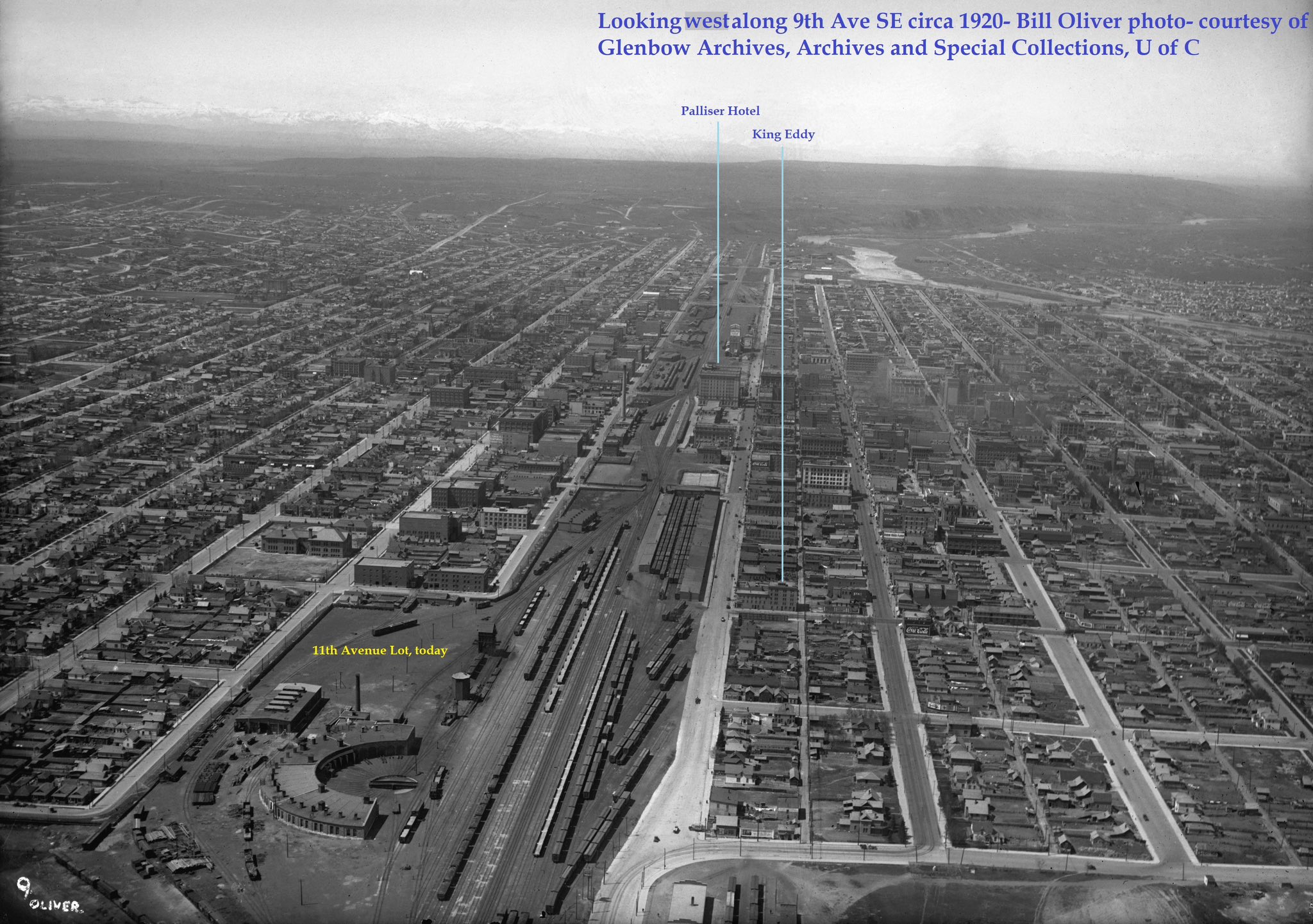
This is a rough approximation of what the photo would look like today. Not as close to the River of course, but the same general direction.

1680457714227.png
 
Hell of a lot more trees now than any time in the last… 40,000 years? Maybe longer? Since at least the last interglacial.
 
Calgary back in 1925. Amazing urban scene of people and streetcars, especially for a city that had less than 100k

View attachment 507737
Good illustration of the secret of vibrancy and urban life - walkability. All you have to do is put enough people close enough together that they walk most places (or can take a short street car). Back in this era it was all intuitive and obvious - why wouldn't we put stuff closer together so people could walk? Cars were still new and limited, street cars worked well.

Modern day examples still exist in many small walkable towns the world over, but closer to home, popular mountain resort towns. Banff doesn't look too dissimilar to this photo - throw 30 - 50,000 daily visitors into a small and walkable core area and you have plenty of activity and supporting retail vibrancy. You don't necessarily need millions of people to have a vibrant street life.

Of course, Calgary (and many other places) don't look like this anymore despite having many times more people overall because we bleached the life out of much of the core with office blocks and wide and unpleasant arterials, while also depopulated much of the inner city to further, car dependent locations. All that car-oriented infrastructure and streets, combined with segregated land uses actively work against walkability that requires short distances - that are ideally also not unpleasant asphalt hellscapes.

Good news is this is all shifting back to a new peak vibrancy period in the future - pockets of the Beltline are heading back towards this level of vibrancy, and it only took 10,000 - 20,000 in population growth in a walkable format to do so in the last decade or two. Fast forward another 50 years of growth and there's 100,000+ in inner city it will be revolutionary to street life here.
 
When you look at that last photo it really makes you wish that Foothills Hospital and University Heights had swapped locations. It would be so handy to have had the university and hospital side by side.
 
When you look at that last photo it really makes you wish that Foothills Hospital and University Heights had swapped locations. It would be so handy to have had the university and hospital side by side.
And just how empty and land-inefficient all our provincial and municipal institutional lands truly are in the NW.

Not pictured, but it's mind blowing that something like the research park can exist since the 1970s and only now realizing they have vast tracts of undeveloped random land and can make a plan to intensify it. Each institutional cluster has it's own version of this land in-efficiency and when you layer in the duplication of green space from the city and the incredibly generous setbacks and buffers on every major corridor in the area and it becomes truly amazing you can have so much stuff clustered together, yet have everything so inaccessible and far apart. Almost every other major city does better at blurring institutions with development - including Edmonton at U of A that famously is under the same jurisdictional framework as everything in Calgary's NW cluster.

In a more rationally planned (or not planned) city, the intensity and demand for access to all these major institutions would have long converted everything to development, and intensified University Heights and all surrounding areas to something more like the Beltline in time.

I know this is unpopular - but I can't stand random green spaces that we keep around for the sake of them being "nice" in the heart of a 1.5 million person city. Make everything green an actual park with stuff in it, and if we can't afford to do that then develop them. We shouldn't leave these random dozens of hectares to just be a empty field in such a prime location.
 
Last edited:
And just how empty and land-inefficient all our provincial and municipal institutional lands truly are in the NW.

Not pictured, but it's mind blowing that something like the research park can exist since the 1970s and only now realizing they have vast tracts of undeveloped random land and can make a plan to intensify it. Each institutional cluster has it's own version of this land in-efficiency and when you layer in the duplication of green space from the city and the incredibly generous setbacks and buffers on every major corridor in the area and it becomes truly amazing you can have so much stuff clustered together, yet have everything so inaccessible and far apart. Almost every other major city does better at blurring institutions with development - including Edmonton at U of A that famously is under the same jurisdictional framework as everything in Calgary's NW cluster.

In a more rationally planned (or not planned) city, the intensity and demand for access to all these major institutions would have long converted everything to development, and intensified University Heights and all surrounding areas to something more like the Beltline in time.

I know this is unpopular - but I can't stand random green spaces for the sake of them being "nice" in the heart of a 1.5 million person city. Make everything green an actual park with stuff in it, and if we can't afford to do that then develop them. We shouldn't leave these random dozens of hectares to just be a empty field in such a prime location.
Couldn't agree more. The other thing worth mentioning is that many of these 'green spaces' aren't really green. They should be called semi-arid grassland spaces.

One thing I always forget is that we used to celebrate our low density and how much space we had. The City of Edmonton used to brag about how it had more space per capita than any other Canadian city. lol. Good thing times have changed.
 
Last edited:
Would be great to a photo of that angle today, and compare.
1699132096695.png


I think these are the differences that are/would be visible in both images -- all additions except for Stadium Shopping Centre (which is addition by subtraction):
1699132983763.png


There are other additions on the U of C campus, the ACH, etc. that wouldn't have been there in the initial picture.
 

Back
Top