News   Apr 03, 2020
 4.6K     1 
News   Apr 02, 2020
 6.5K     3 
News   Apr 02, 2020
 3.7K     0 

Calgary Transit

@Surrealplaces is right about the potential of station refurb. If every station had 4-corner, straight line (not sawtooth pedestrian bridges) connectivity at both ends of the station it could really save an unpleasant <200m walk in many cases and make certain destinations feel much closer to the station.

For instance, imagine if UofC station simply pointed the stairs in the direction of the path. Suddenly an "800m walk to the station" begins 20 m farther west.

Every U of C student ever has said this, 100% correct. It's a nonsense story of competing jurisdictions (City and University) getting in the way of the obvious answer. You'd think since almost all the money for the university and for the LRT came from the same source (Province) they'd at least attempt integration at some level rather than the classic property-line build limit for each party without even considering working together beyond that.
 
The school of engineering could literally build a ramp due west of the stairs (still using the same infrastructure for road crossing) for essentially free with a bit of donated supplies and student labour. Call it a senior prank.
 
A few shots of the BRT Bridge progress at the irrigation canal and Deerfoot, taken last week:


BRT Irrigation Canal Construction IMG_2475
by ferreth, on Flickr


BRT Irrigation Canal Construction IMG_2473
by ferreth, on Flickr

This is the beginning of the fill for the ramp that will be an offshoot taking you down to the west side of the irrigation canal, southbound.

BRT Irrigation Canal Construction IMG_2472
by ferreth, on Flickr

Deerfoot Bridge as seen from the irrigation canal bike path:

BRT Deerfoot Bridge Construction IMG_2477
by ferreth, on Flickr
 
Calgary's turn:


Nice video!

The gap in the system due North is uuuuuugly! I wonder if it would be plausible to extend the airport connection Westward in the heavily residential areas to the North. (Crazier still, send it all the way to the Red Line)

upload_2018-9-19_16-3-33.png


At least as far as where Beddington become Symons Valley Blvd. would be nice! If you had the budget for all 3 lines, then you could disburse the inbound traffic amongst the other lines too instead of just loading up the Green.
 

Attachments

  • upload_2018-9-19_16-3-33.png
    upload_2018-9-19_16-3-33.png
    1.2 MB · Views: 374
This is old, but contemplates service up for the even more central north west:
upload_2018-9-19_16-7-34.png
 

Attachments

  • upload_2018-9-19_16-7-34.png
    upload_2018-9-19_16-7-34.png
    447.4 KB · Views: 369
Drove 17th Ave SE from 52nd to Deerfoot yesterday. Most of the work left to be done is landscaping and concrete work, plus the shelters. It is already looking better, but will set a 'new standard' when everything is wrapped up. I wonder if we will see neighbourhoods/BIAs wanting to benefit from a redo after this.
 
South Crosstown BRT: MAX Teal
North Crosstown BRT: MAX Orange
17th Ave BRT: MAX Purple

MAX-Teal-route-map-1024px.jpg


MAX-Orange-route-map-1024px.jpg

MAX-Purple-route-map-1024px.jpg

2018-BRT-Network-Map-PowerPoint-Size-01-878x1024.jpg

Good presentation and branding IMO.
 
Last edited:
Presented nice...but those off peak service times still bother me. Hell even 18 minute peak time is upsetting.
It will be interesting to see how these lines (and the restructured network) evolve. These headways are disappointing, however it isn't difficult to improve them once riders get used to the new network and baseline travel patterns settle. Even if this BRT setup is lacking some key elements commonly used to improve travel times on BRT networks (no dedicated lanes except 17th Ave SE, no all-door boarding, no off-vehicle payment etc.), there are some big differences over the current state of transit. Most critically, these routes are very direct by Calgary Transit standards, going a long way to reducing Transit travel times right away.

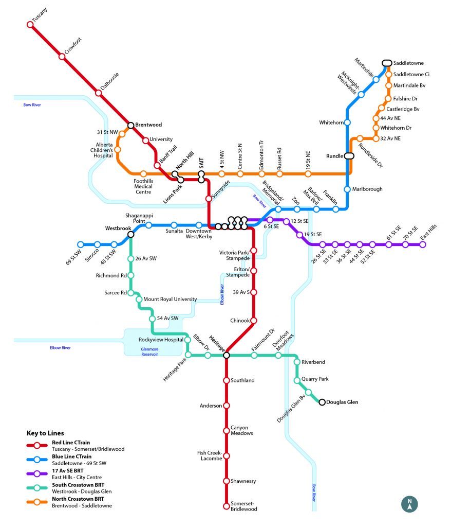
An example: Let's compare a trip from Rundle Station to Foothills Medical Centre. Here's today's trip time for an 8:15am weekday trip using google maps. I chose this time because that is first Orange-MAX trip out of Rundle so assumes no waiting.
  • Car: 16 - 35 minutes, Transit: 59 - 62 minutes (+43 minutes over fastest car), Bike: 46 minutes (+30 minutes over fastest car)
  • Transit has zero transfer (Route 19), or 1 Transfer (Blue to Red)
  • Bike is generous: no real infrastructure for most of the route, hardly welcoming even in perfect weather

November 19th: Car: 16 - 35 minutes, Transit: 31 minutes (+15 minutes over fastest car). A full 28 minutes faster than the fastest transit today.

That's a serious improvement and quite competitive with car trips by Calgary Transit standards (many of our routes run 3 - 4x slower than car trips to similar destinations). Of course, this doesn't factor in delays due to being caught in the same traffic as cars, showing up between buses etc. That is a leg that if you plan for it, will save lots of people, lots of time. Might even pull some people out of vehicles who don't care to pay for Foothills parking anymore. I am sure there are other examples in the MAX network of similar big time improvements.

I hope these routes are thought about by Calgary Transit as backbone infrastructure that can evolve and improve specifically with the lens of BRT: removing stops, add frequency, reduce wait and dwell times through investing in new processes (all door boarding for example). A good day 1 start, but eyes should be on continual evolution to better-and-better BRT, even if we didn't get all the features into the Day 1 operations. No reinventing the wheel here, just follow best practices and they will be a success.
 

Back
Top