Green Line LRT | ?m | ?s | Calgary Transit

A key problem with a political process that is so easily manipulated by vested, current stakeholders and individuals is that the real trade-offs - the ones that could have materially changed the cost or scope - couldn't really seem to be really considered. Consider two examples for which is cheaper. Both create an equally fast and effective LRT system:
  1. LRT added to Centre Street at grade, removing car lanes. To appease some current stakeholders, land is expropriated to allow road to be widened again. This cost is added to the LRT project budget.
  2. LRT added to Centre Street at grade, removing car lanes. The roads department is free to add expropriation and expansion of Centre Street to a future projects list where it get ranked and sorted with all other roads investments. Spoiler alert: vehicle capacity would never be prioritized again on this route so the expansion project would never happen.
Want a cheap, fast and effective transit for all 40km? Easy - get rid of all car access/expansion but keep the route at-grade and give it green light priority at every intersection. Make all funding conditional on zero expropriation of private land and 100% transit priority. Perhaps that's a bit harsh for a real-world example, but I think the principle of it is clear enough.
Is it anticipated that Centre St north of 16th Ave to 64 Ave will still have 4 lanes of traffic for vehicles? I thought it's intended for it to be 2 lanes the whole corridor, and the intersections for turning may be widen for turning lanes?

Centre Street should be converted as a transit corridor, and N-S traffic for North Central to downtown should be encouraged to use 14 Street, Edmonton Trail, and Deerfoot Trail instead.

I hope that's what their plan is. Centre Street being a 4 lane road is completely unnecessary with the LRT in place. In the Livingston/Carrington area, they're actually making Centre Street a transit corridor where the train and active mobility is the priority. The street would only have 1 lane in each direction, and for more through traffic, they'll be deferred to neighboring one way streets. So there is precedent in the planning department to do this.
 
Just came across these updated bridge concepts on the city's website:

Viaduct_West_with_watermark_rev01.jpg

Viaduct_Bluff_View.jpg


Below-Deck_Arch_West__with_watermark_rev01.jpg

Below-Deck_Arch_Bluff_View.jpg


Tied_Arch_West_with_watermark_rev01.jpg

Tied-Arch_Bluff_View.jpg


https://engage.calgary.ca/greenline/bowbridge

So other interesting renderings with view points and landscaping of the area as well.

I think the second / under deck arch concept is my favourite of these. Would be ok with the third / over deck arch as well. Those both best complement the Centre Street Bridge yet have a modern feel, but option 2 is a bit more sophisticated.
Agreed, I like the second option best. Not a fan of the first option.
 
Is it anticipated that Centre St north of 16th Ave to 64 Ave will still have 4 lanes of traffic for vehicles? I thought it's intended for it to be 2 lanes the whole corridor, and the intersections for turning may be widen for turning lanes?
You're correct. That section of Centre Street was always planned to be one lane each way. This is what they're envisioning for it:

eQbfW3a.png


It makes sense when LRT has been built to a useful terminus and replaced many dozen buses per hour as well as car traffic. But I hate to see how it works when the line ends at 16th Avenue and all of the current car and bus traffic on Centre Street hits this new bottleneck:

H7RJ0oF.png
 
I hope that's what their plan is. Centre Street being a 4 lane road is completely unnecessary with the LRT in place. In the Livingston/Carrington area, they're actually making Centre Street a transit corridor where the train and active mobility is the priority. The street would only have 1 lane in each direction, and for more through traffic, they'll be deferred to neighboring one way streets. So there is precedent in the planning department to do this.
The Livingston/Carrington Centre Street example may not be the best. Yes, the transit way is as you described, but the one-way couplet includes at least 4 lanes in each direction if I recall. So really, Centre Street is 10 lanes of traffic, plus the LRT ROW, north of Stoney Trail. Here is the outline plan for Carrington for this portion, including the cross-sections, which shows 1st Street NW as 4 lanes of one way traffic. I haven't pulled the Livingston outline plan for this area, which would include 1st STreet NE, but I presume it would be the same:
1617721875204.png
1617721926911.png


When you look at the size of some of the other cross-sections in that link, I struggle to see how this will be a pleasant, walkable TOD neighbourhood that makes active mobility the priority in the future......

Edit: Okay, a bit of googling and I found the outline plan that shows 1st Street NE. Yep, 4 lanes, one direction. Went to CPC on December 19, 2019:
 
Last edited:
Is it anticipated that Centre St north of 16th Ave to 64 Ave will still have 4 lanes of traffic for vehicles? I thought it's intended for it to be 2 lanes the whole corridor, and the intersections for turning may be widen for turning lanes?

Centre Street should be converted as a transit corridor, and N-S traffic for North Central to downtown should be encouraged to use 14 Street, Edmonton Trail, and Deerfoot Trail instead.

I hope that's what their plan is. Centre Street being a 4 lane road is completely unnecessary with the LRT in place. In the Livingston/Carrington area, they're actually making Centre Street a transit corridor where the train and active mobility is the priority. The street would only have 1 lane in each direction, and for more through traffic, they'll be deferred to neighboring one way streets. So there is precedent in the planning department to do this.
In the section where they are reducing car lanes in favour of transit, there is a ton of expropriation and an overall expansion of the right of way. Part of this may be unavoidable for construction logistics, but much more of it is for adding occasional turning lane and upsizing travel lanes. Centre Street already has 20 - 30m of existing right-of-way from Beddington to Memorial. If you can't fit an at-grade LRT + 2 travel lanes and sidewalks in 25m something is doesn't seem right.
 
Fun portal work:
_h2A91XJJ-WJysIZJQNWyjL9rMqz3EpAT77JkUKzcXaIQnKuaqrU6fXrw2vOqzZw4GNFm3MhxtZW41djWsWoPW4SBdpYkNsj4cNPy_CTEZTjEcmw5r7P8sFMFJlgyTRbEYsELtdAiCs
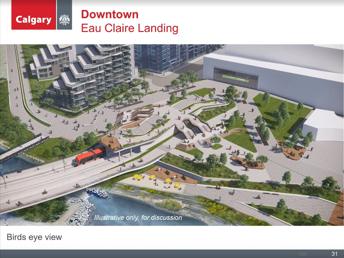
K now I'm down for a bridge! This rendering really emphasizes how badly the Waterfront properties messed up by not adding retail to help activate the riverfront (now they're gonna unknowingly miss another opportunity of activating a park/plaza). Could have been a really well-integrated TOD. Let's see what the Eau Claire redevelopment does to bring some vibrancy.
 
I love that idea. Make the best of a bad situation and completely activating the area around it. Very cool.
 
Now can we just get this approved at all levels so we can start building?
No, because there is still fundamental differences with how the city thinks contracting should go, and the province. And those differences as discussed here amount to a huge black hole cost wise.
 
That Eau Claire landing is a mess. Rarely will people ever go up those steps to a platform that doesn't have a purpose to justify the cost of all of that work. No pedestrians are going to go up steps just to get to the other side. They will go around. A wide and gradual sweeping arc to the south of both path & bike route up and over the line would be much better and simpler. Goal One here should be the simplest and most accessible pedestrian and cycling route east-west through the area.

The east-west pathway route creates major conflict with the entry doors to the station. Not to mention this design hasn't thought one iota about the other seasons, which is typical for this city.
I agree. Pockets of landscaping and multiple overhanging stairs creates ice dripping/snow maintenance issues, random width of pathways intersecting at weird angles will create weird congestion and pinch points all over, despite a big increase in pedestrian area overall.

I would remove all the weird stairs, triple the width of the gradual sweeping arc pathway for both pedestrians and cyclists and the make the size of the mixing zone/station plaza as large as possible in front of the station. Remove as much pointless random grass bits as possible and allow wide sweeping arcs to give real capacity with very wide pathways. This is forever the heart of the pathway network and will always have extremely high traffic. Build it with less landscape architecture flourishes and more sheer capacity.

1618861477715.png
 
Thoughts on the portal:
1) Biggest fail is trying to turn the portal into a plaza
2) Why does the LRT bridge have not only another pedestrian crossing, but one on either side? Pedestrian crossings of the lagoon already exist to the immediate east and immediate west. Keeping the bridge narrower will lessen it visual impact. Creating a redududant north-south pedestrian flow only adds to congestion
3) How about a restaurant building above the portal? I would offer excellent views and be far more utilized than a dead end plaza
4) I'm torn about providing pedestrian passage under the bridge by the portal. It would be dark, prone to ice build up and yet another spot for undesirables to congregate
5) Perhaps a wide ramp in the location of the stairways could minimize the jog in the pathway. Closer to the station, where the ramp is located in the image, could be another restaurant
6) Could the portal and bridge approach be shifted westward so that the pathway wouldn't have to make as sharp of a jog next to the Waterfront. This would likely be cost prohibative but even a 15m shift would make a difference. Perhaps eliminating the pedestrian pathways on either side of the tracks will allow the bridge to shift westward within the footprint shown in the image
7) Maybe enclose the section of the bridge through the park with something like this
1618868580925.png

1)
 

Back
Top