News   Apr 03, 2020
 4.7K     1 
News   Apr 02, 2020
 6.6K     3 
News   Apr 02, 2020
 3.8K     0 

Calgary Bike Lanes and Bike Paths

I often wondered if the Japanese style bike racks could ever be a thing, although I'm not sure how they really secure they are... but they were neat to see in person. From what I could gather, you basically paid at the Kiosk and put in the stall number... then some sort of mechanism would lock your bike in place.


bd8cb0429d939e9d44858d8cf0a2ba40.jpg
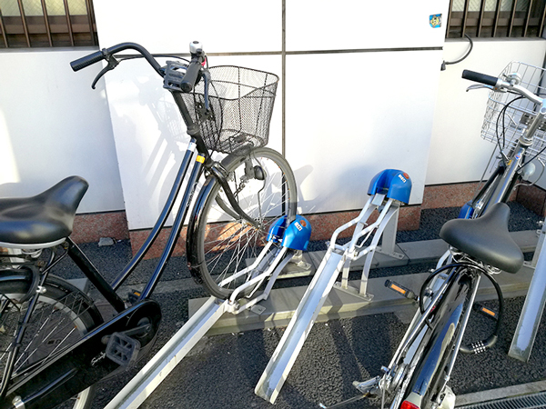
Difficulat to say if it would work here. In Japan, theft is much less a problem than in North America. Cool idea thoh.
 
I have a question about the bike path along the Bow. If a person wanted to bike from Inglewood to Fish Creek, what's the best path route? I took the path as far as Ogden road and then it cut to the other side. Looking at Google maps, it's unclear where the paths go along the Bow River. Thanks!
 
I use the city provide website if I'm not sure what paths go to where. It's usually up to date, There are some small sections of paths here and there that exist but aren't on the map, but generally everything on the map exists. As far as Fish Creek Park goes it's full of paths, but the city's website doesn't show them for some reason.

 
I have a question about the bike path along the Bow. If a person wanted to bike from Inglewood to Fish Creek, what's the best path route? I took the path as far as Ogden road and then it cut to the other side. Looking at Google maps, it's unclear where the paths go along the Bow River. Thanks!
You were on the right track, until the new segment opens up on the Bonnybrook side (there's nothing I've been able to find online about completion timelines on this one) you cross the river at Ogden and head through Refinery Park and Beaver Dam Flats. Then you kind of have a choice of either side of the river at Glenmore, both will connect you through to Fish Creek.

Check out the site Surrealplaces posted above, or sometimes I'll check a place like Strava to reality check routes as well.
 
I'd recommend staying on the east side of the river. As you come down the hill from Lynnview Ridge/Ogden go underneath the Glenmore Trail bridge and continue through Carburn Park. Stick to the east side until you've gone underneath Deerfoot Trail and then cross the pathway bridge at Douglasdale to head back to the west side and into Fish Creek. Annie's Cafe in Fish Creek makes a great place to pit stop before you turn around and head back.
 
I'd recommend staying on the east side of the river. As you come down the hill from Lynnview Ridge/Ogden go underneath the Glenmore Trail bridge and continue through Carburn Park. Stick to the east side until you've gone underneath Deerfoot Trail and then cross the pathway bridge at Douglasdale to head back to the west side and into Fish Creek. Annie's Cafe in Fish Creek makes a great place to pit stop before you turn around and head back.
That's the route I took last time I cycled down to Fish Creek, and I would agree, it's the best path to take.
You were on the right track, until the new segment opens up on the Bonnybrook side (there's nothing I've been able to find online about completion timelines on this one) you cross the river at Ogden and head through Refinery Park and Beaver Dam Flats. Then you kind of have a choice of either side of the river at Glenmore, both will connect you through to Fish Creek.

Check out the site Surrealplaces posted above, or sometimes I'll check a place like Strava to reality check routes as well.
I haven't been that way for a while, but that cut off is kind of a pain. It'll be so nice when they get that Bonnybrook stretch open again.
 
Thanks for the advice everyone! One more newb question folks here might be able to answer. I remember the original plan for the downtown cycle tracks included on for 8th street SW, I take it, it never went ahead? or still in planning?
 
Thanks for the advice everyone! One more newb question folks here might be able to answer. I remember the original plan for the downtown cycle tracks included on for 8th street SW, I take it, it never went ahead? or still in planning?
The original plan was what was implemented, a shared space for both bicycles and pedestrians but with counter-flow cycling allowed plus the protected cycle lanes west of 3rd Street SW. I think the counter-flow park and some markings on the pavement/ new eastbound signals are the only real physical changes between 3rd Street and City Hall IIRC.

EDIT - Sorry misred 8th Ave not Street!
 
Last edited:
Thanks for the advice everyone! One more newb question folks here might be able to answer. I remember the original plan for the downtown cycle tracks included on for 8th street SW, I take it, it never went ahead? or still in planning?
8th St (not Ave) had a corridor study done from 2012-2016; the underpass improvements were associated with this. The study had painted bike gutters lanes between 8th and 12th Ave; with four lanes of traffic north of that (where the traffic volume is 2/3 that of the 8th-to-12th segment) and four lanes of traffic with offpeak parking south of that. Five phases were identified; phase 1 was the underpass at 7 million; seems like the bike lanes were forgotten in the underpass phase (whoopsie-doopsie). Phase 2 ($7.5M) would be the section from 10th to 13th. The rest of the corridor was $30 million or so, $18M of that was phase 5 - 8th to 4th Ave.

It's been crickets since the underpass; not something that's even been touched. It's depressing, really, especially to look at a map that has The Mark on 10th noted as DP approved, the mixed use with Canadian Tire as "preliminary discussion" and even everlasting Century Park renos as 'preliminary design", and see phase 1 of 5 is not even completed. (The upgraded underpass is described as 'interim'; the ultimate includes the creation of park/ramp space on either side of the street in the area, as well as, you know, two $50 bike lanes painted on the street.)
 
I still don't get why the city won't protect the bike lanes on 11st North of 12Ave. I see cars go into the bike lanes all the time to go around another car turning at a light, with no looks ever given to whether there is a cyclist there. I've probably called 311 100x on it and each time they say there are no plans to make changes at this time. I swear someone needs to get killed there before the city pays attention!

Speaking of calling 311 a million times for no result. The contractors working on district use the 12 Ave bike lane as a loading zone pretty much every day, and the city never seems to do anything. I've been driving more lately and might continue to do so long term as I find cycling too dangerous and frustrating in the cycle network.
 

Back
Top